Customer
Council for Scientific and Industrial Research (CSIR)
Mission Location
The Southern Ocean
Highlights
- Collected an unprecedented high-resolution CO2 data set in a difficult location
- Sampled continuously between ship visits to monitor progress in real-time
- Gathered a full seasonal cycle of data at a far lower cost than shops
“Our ability to better understand how the ocean interacts with our climate is critical to our future. New tools such as the Wave Glider give us data and capabilities not previously possible, advancing our ability to link global climate issues to local level drivers.”
The Challenge
To expand and accelerate their research efforts, the Council for Scientific and Industrial Research (CSIR) needed to overcome the difficulty and cost of collecting meaningful ocean data at the space and time scales that deliver maximum value. The traditional methods of gathering ocean and environmental data (ships, satellites, and buoys) were either too expensive or too inflexible for these requirements. The SA Agulhas II, South Africa’s polar research vessel, costs about R300,000 (~$20,000 USD) a day to operate, but can only take snapshots of ocean conditions. Moorings with sensors are less expensive than ships, but limited to their location. Researchers needed a way to gather high-resolution observations over an area of the ocean, repeatedly, for an extended duration of time.
Tackling Global Climate Challenges Locally
The Southern Ocean, accounts for 50% of all carbon dioxide absorbed by the ocean, 80% of the heat uptake and supplies nutrients that support 75% of ocean productivity outside polar regions1, yet researchers know little about its sensitivity to climate change.
The Solution
To improve the focus on the Southern Ocean, CSIR created a consortium called the Southern Ocean Carbon and Climate Observatory (SOCCO). In 2012, SOCCO started a large-scale, multi-year experiment called the Southern Ocean Seasonal Cycle Experiment (SOSCEx) with the goal of shifting away from historical ship-based modeling of the Southern Ocean to a system-scale dynamics study that uses robots to gather seasonal scale data with greater time and space2 frequency.
Wave Gliders play a critical role in this effort with the ability to gather data at the surface of the ocean in defined areas, over long durations (months), and in difficult sea conditions. Real-time communications also provide critical updates on data and vehicle status.
Better Data and Measurements with Ocean Robots
In the last 2 cycles of experiments, SOSCEx II (2013/2014) and SOSCEx III (2015/2016), the combination of robot gliders working at the surface (Wave Gliders) and deep in the ocean (profiling buoyancy SeaGlidersTM) has given CSIR and the broader team new insights. In SOSCEx II, the team got an unprecedented high resolution CO2 data set in a quasi-fixed and difficult location that offered a picture of the fine-scale links between surface and sub-surface changes in water and air over a time period of 4 months.
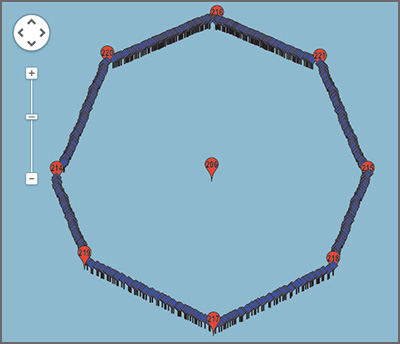
A map showing the octagon navigation pattern followed by a Wave Glider to gather data in one location over a long duration.
In SOSCEx III, ships and robots work together, with ships gathering biogeochemical measurements at a given location and robot gliders sampling continuously between ship visits. The long duration capabilities of the Wave Glider allow scientists to get a full seasonal cycle of data at a far lower cost and to monitor the progress in real-time via satellite.
Results to Date
CSIR and Southern Ocean Carbon-Climate Observatory (SOCCO) researchers have published research that documents why a sampling strategy with ships and biogeochemical floats alone will not be sufficient to reduce the uncertainty of flux CO2 (fCO2) measurements in the Southern Ocean below 10%. Their research proposes the need for a more adaptive sampling frequency between 1 and 30 days, depending on the region and season. This is something that can only be done with the help of Wave Gliders together as part of a constellation of platforms including Argo floats and ships.
What’s Next?
The CSIR and SOCCO teams are continuing their annual Southern Ocean experiments with the long-term goal of improving the way global climate models reflect CO2 and primary productivity climate sensitivities in the Southern Ocean. Key data for this research is only possible through new data collection methods that use both unmanned surface vehicles like the Wave Glider and sub-surface buoyancy gliders.
1 CSIR, Ocean Systems & Climate, http://www.csir.co.za/nre/coasts_and_oceans/osc.html
2 Swart S, Chang N, Fauchereau, et al. Southern Ocean Seasonal Cycle Experiment 2012: Seasonal scale climate and carbon cycle links. S Afr J Sci. 2012;108(3/4), Art. #1089, 3 pages. http://dx.doi.org/10.4102/sajs.v108i3/4.1089