GEOMAR Offers a Fresh View on Wave Glider Missions
Liquid Robotics — March 2, 2017
How do you explain the power of autonomous systems to change how we see and understand activity in the ocean? One great way is to allow people to see just what those unmanned vehicles are doing. A test-drive or simulation is a great, but the opportunity to see missions in real-time heightens both the experience and the desire to know more.
The GEOMAR Helmholtz Centre for Ocean Research in Kiel Germany, one of our customers, recently announced an impressive web-based portal, called GEOMAR Navigator, for tracking their Wave Glider missions and accessing data from them. The Navigator portal was developed as part of a scientific cooperation with Oman where future missions with Wave Gliders will occur. That said, the portal will serve a wide range of mission needs.
GEOMAR Navigator offers a smooth and intuitive interface for learning about current and past Wave Glider missions including the activity of other vehicles such as a buoyancy glider, involved in the mission. If you’re new to this type of interface, don’t worry, the home screen offers a friendly and efficient tour. You can quickly see both active and recent missions and the details behind each of their 3 vehicles.
As of this post, there is an active mission that you can view in real-time. This mission involves two Wave Gliders and a buoyancy profiler (Slocum G2-1000) around a seamount near the Cape Verde Islands (off the West Africa coast). The full details of this mission that deployed from the RV Maria S Merian and includes a group of American and German scientists is well described by one of the participating institutions, PLOCAN, in this post.
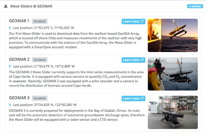
GEOMAR Navigator – Vehicle Information at a glance
In addition to viewing detail about the missions (e.g. courses, velocities, past tracks), additional environmental information such as cloud cover, currents, ship traffic, and other sensor data can be superimposed on the screen.
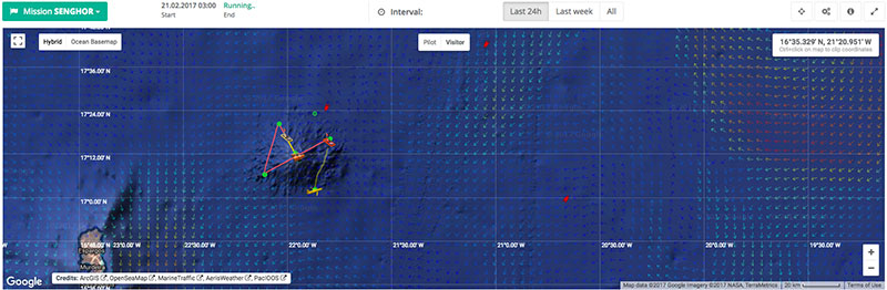
Map showing Wave Glider course, current data (arrows), and ship traffic (red arrows)
Finally, checking the status of individual vehicles, including environmental data (air, wind, and current), via telemetry data, is a snap.
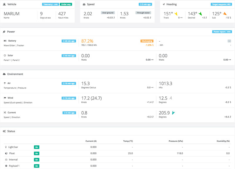
Vehicle telemetry from Wave Glider Marum
What I love most about the GEOMAR Navigator is that it allows anyone to quickly understand missions and the type of data that can be collected by unmanned systems like the Wave Glider. While Liquid Robotics’ Mission Management Software provides the APIs necessary to allow customers to share and extract data from missions and vehicles, it is ultimately up to individual customers to decide how they will share their data.
I encourage you to check out the GEOMAR Navigator portal, especially while a mission is live and read about some of the incredible research and collaboration done by this team. From biomass, CO2, and O2 time-series observations near Cape Verde, to seismic monitoring as part of the seafloor-based GeoSEA Array off the coast of Chile, they are doing some great work.
Here are some useful resources to get you started:
GEOMAR Navigator press release (February 22, 2017)
