GLIDER Unmanned Ocean Exploration – Advancing Knowledge of Arctic Marine Ecosystems
Guest Contributor — September 10, 2018
In the context of increased industrial activity in the Arctic, much attention is given to the potential effects on ecosystems considered sensitive by authorities and the community. Among these areas we find the Lofoten-Vesterålen islands on the Norwegian continental shelf, known for their highly productive fisheries and tourism industry, and the North East part of the Barents Sea which is close to the productive polar front and the ice edge. As exploration licenses have been awarded in these areas, there is a demand from Norwegian authorities for a thorough characterization of these ecosystems and for data for environmental risk and impact assessment, impact prediction models, net environmental benefit analysis and finally for biomonitoring throughout the lifetime of industry projects.
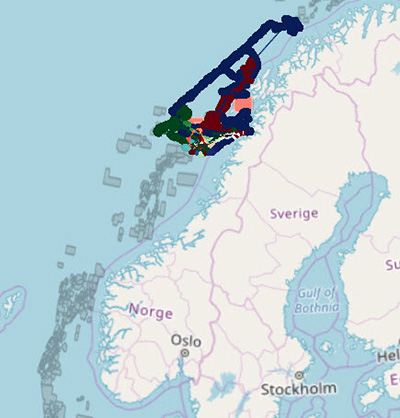
GLIDER tracks from the survey
The primary objective of the GLIDER project, managed by Akvaplan-niva, is to demonstrate a cost-effective observation program for real-time and long-term integrated environmental monitoring in sensitive areas over a large spatial scale. Included in this the goal of increasing the amount of high quality ocean data and facilitating more flexible sampling methods compared to traditional concepts.
The observation program consists of three emission free, self-propelled platforms, a Seaglider (by Kongsberg), a Sailbuoy (by Offshore Sensing), and a Wave Glider. The Wave Glider is operated by Liquid Robotics Open Oceans Channel Partner in Scandinavia, Maritime Robotics. Each vehicle is equipped with multiple sensors, connecting seafloor to space for real-time ocean data collection, complementing each other with different operational profiles. Sensors on the Wave Glider include the SIMRAD WBT Mini fisheries echo sounder, Aanderaa, oxygen, and carbon dioxide optodes, temperature, fluorescence, turbidity, and a hydrophone to capture marine mammal vocalizations.
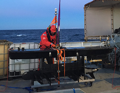
The Wave Glider being prepared for deployment
To ensure this ocean data can be visualized and utilized the GLIDER team has also developed an e-platform to enable analysis of the collected data. The e-platform ensures us both a robust storage method (Kongsberg), a visualization tool (NORCE), and the ability to interpret and use the data for different end users (oil and gas, fisheries, aquaculture, mining, government, etc.).
After an initial trial deployment of just over a month in 2017 the three platforms have been deployed outside Lofoten and Vesterålen in Norway since March 2018 and are due for recovery in September 2018.
Quality control is essential to deliver data from the GLIDER project that are reliable and can be trusted. Operating 24/7 on the incoming data, the quality control module developed by the Norwegian Institute of Water Research (NIVA) uses the approach recommended by the EU program Copernicus. The quality control performs a number of tests on each data point coming from each sensor on each platform.
Whilst the large amounts of acoustic data are periodically offloaded from the vehicles and post processed for analysis, real-time data is being used directly in the Norwegian Meteorological Institute oceanography model for improved weather forecast.
Analysis of collected data shows that the GLIDER concept contributes to increased knowledge of the dynamics and timing of biological events across a large geographic area and time scale. Summing up, the aim of the GLIDER project is to:
- provide large-scale basic data;
- professional solutions for all industries operating in the marine environment;
- obtain scientific data to improve the knowledge of the ecosystem; and
- input to existing models (oceanography, weather and ecology)
The second season operating above the Arctic circle is now nearly complete, and the unmanned vehicles have sailed more than 10,000 km continuously capturing data. The results so far demonstrate that the GLIDER project is set to advance our understanding of marine ecosystems in the region.
The GLIDER project is managed by Akvaplan-niva and funded by the Demo2000 program of the Research Council of Norway and ConocoPhillips Norway.
Partners of the GLIDER project are the Norwegian Institute for Water Research (NIVA), UiT The Arctic University of Norway, Nord University, NORCE, the Norwegian Meteorological Institute, Aanderaa, Offshore Sensing, Kongsberg Maritime and Kongsberg Digital.
For more information on the Wave Glider integration for GLIDER please visit Maritime Robotics.
For more information on the GLIDER project, visit Akvaplan-niva.
