Monitoring Marine Litter in the Mediterranean Sea
Guest Contributor — December 23, 2019
Guest post by Francois Galgani, IFREMER
Because of its energy independence, its long-duration persistence and its cost-effective operation, the Wave Glider platform is able to collect and transmit data over distances of thousands of miles across wide geographic areas and specific areas of interest and operation. Many applications have been described but to date, the use of video has not been tested for regular and long distance surveys. A first application of video camera to monitor surface/subsurface marine litter at sea was tested in 2013 (Galgani et al., 2013), using a a HD GoPro HERO2 Long-Play camera in resistant tube fixed on ballast, sea surface oriented to enable observation in the 0-4.5 meters subsurface layer. A speed never above 1.5 knots and the immersion of the camera provided consistent and stable images along straights routes.
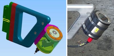
Camera system design by IFREMER
During an additional experiment performed recently by IFREMER and Lamma using a Wave Glider (SV3 066, Lamma/IFREMER), the video system was replaced by a camera in order to facilitate the management and storage of data (images) and to support the future development of a data screening system using an image analysis software.
The robustness of the system was tested in July 2018 during a 4.5 day survey, and retested in 2019 in a large pelagic protected area (Pelagos Sanctuary, North Western Mediterranean Sea; analysis of 2019 data in progress).
In order to save space and autonomy, the prototype camera was supplied on board through a solar panel, allowing continuous use. The choice was made to shoot in “Photo” mode using a GoPro HERO3, with an acquisition every 7 seconds to limit the number of images, enabling full coverage of the track without overlapping images. The camera (256 GB memory card) was mounted on the sub ballast, oriented at 45° for a surface coverage of 12.4 meters in width.
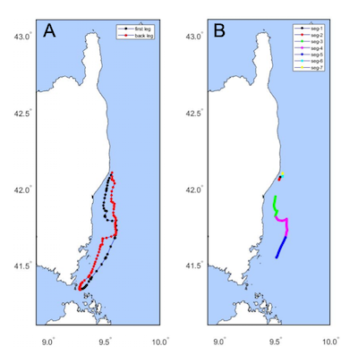
(A) 13 day route; (B) 7 sequences with operating camera
Good quality images were obtained enabling observations of both litter and large planktonic organisms or fish. Approximately 45,000 images were obtained over a period of 4.5 days (images taken between 07:00 and 21:00).
In July 2018, a survey was performed to test the possible long range survey of subsurface marine litter. The survey was possible with consistent data and 45,000 stable images recorded, enabling an assessment of marine debris in the sub surface layer (0-4.5m). 6 debris per km2 were counted, in the range of visual observations (Suaria et al., 2017).
Results showed the possible long-term and large scale utilization of the Wave Glider as a tool for monitoring marine litter. It is well adapted to cover large coastal or oceanic zones, including large MPAs, to monitor surface (0-4.5m) debris, and demonstrates strong potential for remote areas.
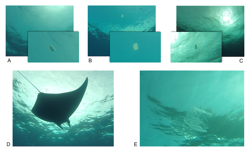
Images collected at sea by the Wave Glider: (A), (B) & (C) subsurface marine litter. (D) Sample of Modula modula macrofauna. (E) plankton species (unidentified).
Learn more about the work IFREMER does to understand our oceans.
Photos: S.D’entrecolas and F. Galgani/IFREMER
