Research Roundup: Acoustic Tag Tracking, Animal Biotelemetry, and GNSS
Liquid Robotics — February 5, 2019
We’re always excited to see how researchers are using Wave Gliders in new and creative ways, exploring what’s possible when you use technology to move beyond the limitations of traditional methods, combined with rigorous scientific validations.
Here are three recent examples that have us excited for the future.
A New Method of Tracking Targets Using Acoustic Tags
On land, startups like Tile and others are helping us tag our items to make them easier to find when we misplace them. Could a similar practice work in the ocean, putting tags on instrumentation to make it easier to locate them? One challenge: Acoustic tags can only convey their presence or absence; they don’t have any inherent location awareness built-in.
Researchers from the Universitat Politecnica de Catalunya, the Jaume Almera Earth Sciences Institute and the Marine Science Institute in Barcelona, in collaboration with MBARI, recently completed the first experiments testing a new method for locating and following tagged targets. Specifically, a test was conducted to acoustically localize a benthic Rover deployed at 4000 m depth using a Wave Glider.
From the paper:
“This paper presents a novelty Area-Only target tracking method, using a Wave Glider autonomous surface vehicle that detects a tagged underwater target while moving on the surface. Using the detection/no-detection information, it is able to compute target position and follow it… The method presented in this paper can be used in a wide range of applications using the long-duration, autonomous navigation and computational characteristics of the Wave Glider, to locate stationary or slowly moving tagged targets on the seabed or in the water column.”
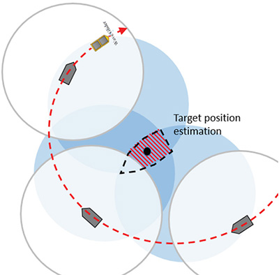
Area-Only target tracking problem representation
Read More
Acoustic tag tracking: first experiments
Masmitjà Rusiñol, Ivan, Spartacus Gomáriz Castro, Joaquín del Río Fernandez, B. Kieft, Thomas O’Reilly, Jacopo Aguzzi, and P. J. Bouvet. “Acoustic tag tracking: first experiments.” In Instrumentation viewpoint, no. 20, pp. 28-29. SARTI, 2018.
Validating the Efficiency of Acoustic Biotelemetry Sensors on Wave Gliders
Unmanned surface vehicles can help researchers break free of the constraints of stationary acoustic receivers, opening up new possibilities for tracking animal migrations and mapping habitats in real time.
Researchers from Scripps Institution of Oceanography and the Institute of Marine Science at the University of California, Santa Cruz, set out to validate whether Wave Gliders could effectively help supplement stationary arrays of acoustic receivers.
From the abstract:
“Mobile autonomous platforms are becoming important tools that support the science of understanding biophysical relationships because they can concurrently detect tagged individuals and measure properties of their ocean habitat. To assess the effectiveness of these emerging platforms, proper validation and range detection studies are necessary. Here, we report on the deployment of a wave powered unmanned surface vessel, the Liquid Robotics Wave Glider SV3, equipped with a forward- and backward-facing acoustic receiver (VR2W) and transceiver (VR2Tx) at 4 m depth.”
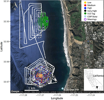
Wave Glider path and location of acoustic detections
Read More
Detection efficiency of acoustic biotelemetry sensors on Wave Gliders
Cimino, Megan, Michael Cassen, Sophia Merrifield, and Eric Terrill. “Detection efficiency of acoustic biotelemetry sensors on Wave Gliders.” Animal Biotelemetry 6, no. 1 (2018): 16.
Sea Surface Height Measurement Using a GNSS Receiver on a Wave Glider
Accurate sea surface height measurements are needed for a variety of coastal conservation efforts, ranging from studies on coastal erosion to understanding coastal ecosystems and climate change.
Researchers from Newcastle University and National Oceanography Centre in the UK equipped a Wave Glider with a geodetic Global Navigation Satellite Systems (GNSS) receiver, in order to overcome the spatial resolution limitations of sea surface height instruments such as tide gauges, satellite altimetry, and GNSS buoys.
Key points from the research letter:
- “GNSS Wave Glider measures instantaneous sea surface heights with centimetric precision in the North Sea, in winds gusting up to 20 m/s
- Hourly dynamic ocean topography measurements agree with high-resolution assimilation model values to 6.1 cm standard deviation
- Measured significant wave heights agree with the WAVEWATCH III model and wave buoy data to 17–24 cm and dominant wave periods to 1.4 s”
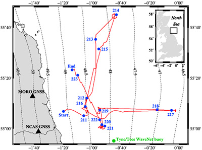
The Wave Glider’s track (red line), with its location each day denoted by the blue circles and labels.
Read More
Sea Surface Height Measurement Using a GNSS Wave Glider
Penna, Nigel T., Miguel A. Morales Maqueda, Ian Martin, Jing Guo, and Peter R. Foden. “Sea Surface Height Measurement Using a GNSS Wave Glider.” Geophysical Research Letters (2018).
For more examples of cutting-edge research enabled by Wave Gliders, check out our Published Research page.
